 | |
|
NAVIGATION Home Hawaii Info Geography Flora & Fauna People Culture Economy Political ...about Kauai Hawaii Maps Kauai Oahu Maui & Lanai Big Island Hawaii Weather Hawaii Calendar Scenic Tours Music Links CLICK TO SHOP Hawaiian Music Search for: Artist/Title |
Hawaii Geography and Climate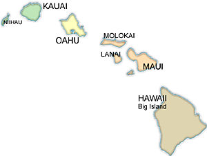 Hawaii, the 50th state (Statehood on Aug. 21, 1959) of the United States of America, consists of a group of volcanic islands in the central Pacific Ocean.
The land area of these islands are the emerged tops of a chain of volcanic mountains that form eight major islands and 124 islets, stretching in a 1,500-mile crescent from Kure Island in the west to the island of Hawaii in the east, encompassing an area of 6,459 square miles (16,729 square km). The eight major islands at the eastern end of the chain are, from west to east, Niihau, Kauai, Oahu, Molokai, Lanai, Kahoolawe, Maui, and the Big Island of Hawaii. Volcanic activity has become dormant, with the exception of the volcanoes of Mauna Loa and Kilauea on the easternmost and largest island, Hawaii, where spectacular eruptions and lava flows take place from time to time. The highest Hawaiian mountains are Mauna Kea and Mauna Loa, reaching 13,796 feet (4,205 m) and 13,678 feet (4,169 m) above sea level, respectively. There is little erosion in the geologically young areas, where the terrain is domelike and the volcanic craters are clearly defined. In the older areas the mountains have been shaped and eroded by the action of sea, rain, and wind. Their aspects thus include sharp and craggy silhouettes; abrupt, vertically grooved cliffs pocked with caves; deep valleys; collapsed craters (calderas); and coastal plains. The powerful Pacific surf, churning and crashing against the fringing coral shelves and the lava shorelines, has carried minute shells onto the shore and reduced coral and large shells to sand, creating the state's famous expanses of beach. Volcanic ash, gravel, rotted vegetation, crumbling lava, and windblown sand and dust all help to make up the alluvial, residual, and organic soils found in various depths and densities in valley floors, the regions between mountain ranges, and along the shores. Oxidation of iron causes a ubiquitous bright red soil and rock strata. Because the topography is generally abruptly descending or sloping, there are few surface collecting basins or lakes. Excess rainfall seeps through porous mountain areas to collect in subterranean chambers and layers retained by less permeable lava and ash beds, or it is prevented by underlying salt water from seeping to the sea. The resultant artesian water supply is tapped for use in irrigation and also for human consumption. Heavy rainfall in mountainous areas produces an extremely voluminous runoff, which is responsible for the erosion that forms the numerous grooves, ridges, and V-shaped valleys characteristic of the older volcanic islands such as Kauai and Oahu. The action of rain combined with waves has had a particularly dramatic effect on the more exposed windward sections of the islands. Hawaii lies just below the tropic of Cancer, and its mild tropical climate is considered by many people to be the world's ideal. Although often humid by U.S. mainland standards, temperatures are conditioned by the northeast trade winds, which prevail most of the year. Blowing for many miles over the open Pacific, the trade winds pass along the great reservoir's stabilizing influence, to make living on the islands delightfully comfortable. The average temperature in downtown Honolulu is 72 F (22 C) in the coolest month and 78 F (26 C) in the warmest, with extremes from 57 F (14 C) to 88 F (31 C) having been recorded there. The average water temperatures off Waikiki Beach, near Honolulu, range from 75 F (24 C) in late February to 79 F (26 C) in late September. Mountainous regions are considerably cooler, especially during the winter months, when there can be frost; a temperature of 1.4 F (-17 C) has been recorded on the summit of Mauna Kea, and winter snows frequently blanket the crests of Mauna Kea and Mauna Loa. Rainfall variations throughout the state are dramatic. Mount Waialeale, on the island of Kauai, is often called the wettest spot on Earth, with an annual average rainfall of 444 inches (11,280 mm) over a 60-year period, the highest long-term median on record. The driest area is at Kawaihae, on the island of Hawaii, where the average annual rainfall is only 8.7 inches (220 mm). The average yearly rainfall in Honolulu is 23 inches, and in Hilo it is 129 inches. As moisture-laden air is carried over the islands, most frequently by the trade winds, it is apt to condense, form cap clouds, and dissipate against the shores and mountains of the windward coasts, which are therefore more lush in foliage than the leeward coasts. |
|
[Home] - [Search for Artist/Title] - [Complete Listing] - [Hawaii Info] - [Links] - [Contact Information] Call Toll-Free 1-800-252-7731 -or- email hawaiianmusicstore@gmail.com | |